

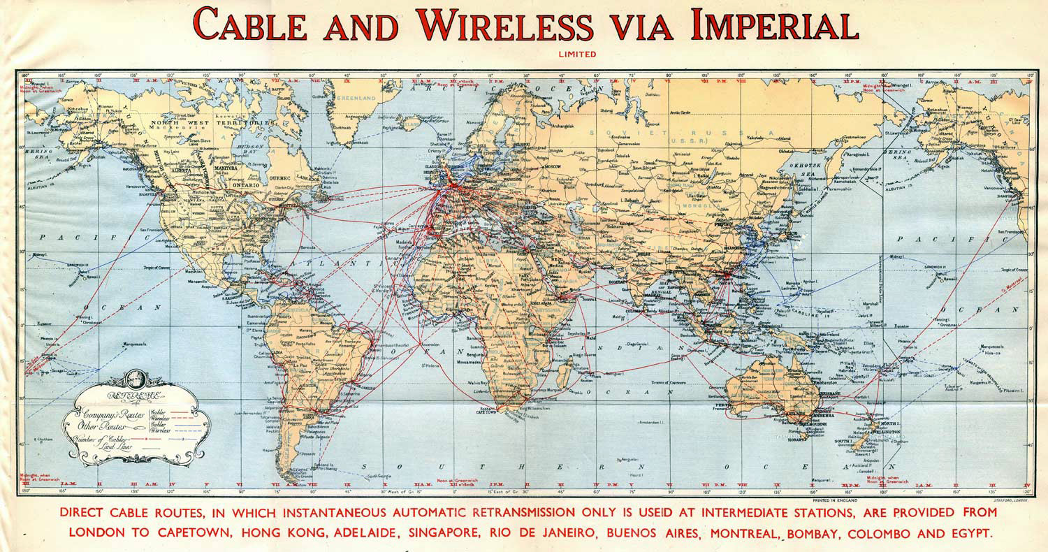
The 1947 map titled "Cable and Wireless via Imperial" offers more than a visual record of global telecommunication routes—it encapsulates nearly a century of imperial ambition, commercial coordination, and technological evolution. With red lines tracing submarine cables and blue dashed arcs denoting wireless links, the map centres London as the hub of a vast communicative web, stretching from Cape Town to Hong Kong, Montreal to Bombay. It reflects a network that began in the age of copper and gutta-percha and matured into one of the most sophisticated systems of global messaging the world had seen.
The origins of this network lie in the mid-nineteenth century, when the Colonial Office—often prompted by the Dominions—collaborated with Sir John Pender and his Eastern and Associated Telegraph Companies to connect the farthest reaches of the British Empire. Between 1860 and 1900, a series of cables were laid that linked the UK through the Mediterranean, across Egypt, and down the Red Sea to Aden and Bombay. From there, the system extended across India to Madras, Penang, Rangoon, and Singapore, with further branches reaching Foochow and Shanghai. Australia was added via the Dutch East Indies to Port Darwin, while Africa was connected through Portugal, Madeira, and St Vincent to Bathurst, with coastal loops running down to Cape Town and up the eastern seaboard to Mombasa, Zanzibar, Seychelles, and Mauritius.
By 1890, this cable infrastructure was influencing and controlling over one billion pounds sterling in annual imperial commerce. Yet its strategic value was equally profound. The South African War of 1899–1902 underscored the consequences of delayed communication. A breakdown in negotiations between the Colonial Office and the Governor of the Cape—exacerbated by slow cable routing—may well have contributed to the conflict. In response, a direct cable was laid from Cape Town to St Helena, Ascension Island, and St Vincent, linking more efficiently back to the UK. In 1901, a further cable between Australia and South Africa, also connecting Mauritius to Durban, supported troop coordination and reflected growing inter-Dominion rivalry. Eastern Australian states, meanwhile, backed a trans-Pacific cable linking Norfolk Island, Suva, Fanning Island, and Vancouver.
This network formed the nucleus of imperial communications well into the mid-twentieth century. From the early 1900s, wireless telegraphy began to supplement cable routes, enabling the first telephone transmissions and expanding reach into previously inaccessible regions. The merger of Eastern Telegraph with Marconi’s wireless interests in 1935 created Cable and Wireless Ltd., headquartered at Plectra House on the Thames Embankment—a symbol of modernity and imperial coordination.
Although Cable and Wireless was nationalised on 1 December 1947, with a mandate to operate telecommunications outside the UK, the map reflects the company’s continued global presence. Despite the rise of national control over communications in many Commonwealth countries, C&W maintained over 155,000 nautical miles of cable and operated from more than 130 stations abroad. In remote outposts and strategic relay points, the company remained closely tied to HMOCS, sustaining a shared culture of service and technical excellence through a period of profound geopolitical change.
Even after privatisation in November 1981, Cable and Wireless retained its Commonwealth footprint, adapting to new licence regimes and technologies. The 1947 map, with its confident geometry and imperial reach, stands as a testament to a time when cables and signals stitched together a global system—one that carried not just messages, but the rhythms of empire itself.

