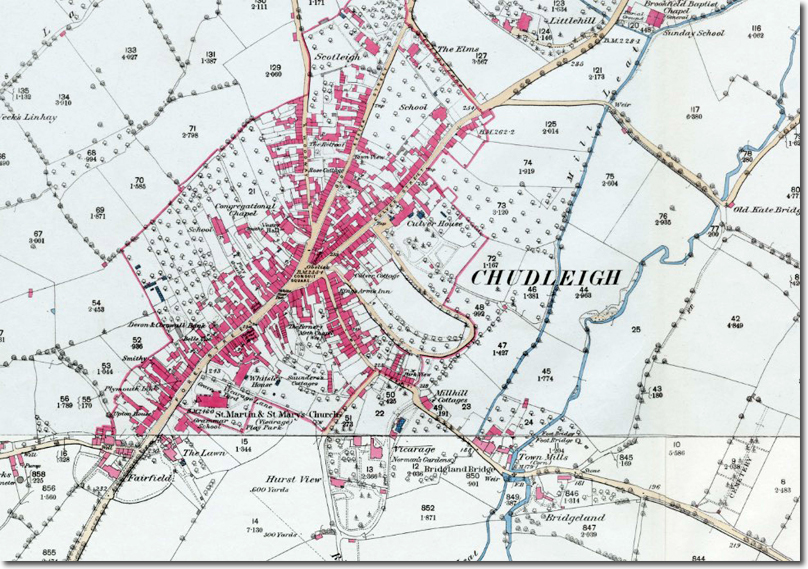
The 1870s map of Chudleigh captures the town at the point where its medieval street pattern, post‑fire rebuilding and nineteenth‑century expansion meet. The long north–south High Street, the church at its centre, and the lanes running east and west reflect a layout established in the Middle Ages, when Chudleigh developed as a small market town on the route between Exeter and the South Hams. The map shows the town before the later twentieth‑century housing growth, when the surrounding fields still pressed close to the built edge and the parish retained its compact form.
Chudleigh’s early history is shaped by its position between the Haldon ridge and the Teign valley. The manor belonged to the Bishop of Exeter in the medieval period, and the parish church of St Mary and St Martin preserves work from the thirteenth century onwards. The town suffered a major fire in 1807, after which much of the High Street was rebuilt in brick and render, giving it the appearance recorded in early Victorian engravings. The 1870s map shows this rebuilt core, with the churchyard, the market area and the principal inns still forming the centre of local life.
The map also records the industrial and agricultural landscape that surrounded the town. Limekilns, quarries and small workshops appear on its margins, while the fields to the east and west retain the pattern of medieval strip enclosures and later consolidation. The road network is recognisably modern, with the routes to Exeter, Newton Abbot, Bovey Tracey and Teignmouth already established. The railway, however, lay at some distance, and Chudleigh remained a road‑based community until the twentieth century.
Several of the families associated with the parish in the nineteenth century appear in the wider historical record: the Parkers of Whiteway, the Cliffords of Ugbrooke, the Farquhars, and the local clergy and tradesmen whose names recur in parish registers and directories. The 1870s map provides the geographical framework for these connections, showing the town as it was known to the generations whose memorials fill the church and cemetery.
Although Chudleigh has expanded considerably since the 1870s, the map preserves the structure of the historic town and the relationship between its centre, its outlying farms and its surrounding landscape. It remains a key document for understanding the development of the parish and the setting of the buildings and families described elsewhere in this series.