|
After finishing my DPhil at Oxford I applied to join the Colonial Geological
Survey, hoping for a post in Fiji. None being available there, I accepted the
offer of one in the Solomons. After all, they were in the Pacific too, if 2000km
distant. My outward journey was one in which - as the size of the aircraft became
smaller (Bristol Britannia to Sydney, Lockheed Constellation to Port Moresby,
Douglas DC4 to Rabaul, DC3 to Honiara) the humidity grew greater. On landing at
Henderson Field on Guadalcanal, accustomed as I was to the bleak mountains of
Skye, I wondered how anyone could survive in this place.
The Chief Geologist, on leave in Australia getting married, had left as my first job
the making of a theodolite survey of the upraised coral terraces around Honiara in
preparation for future housing developments. I had fortunately learned this skill from
the legendary Brigadier Bomford, Reader in Geodesy at Oxford, by carrying out a
survey of the University Parks. My next assignment was real geology: exploratory
survey and mapping of the Betilonga district high in the mountains of Guadalcanal
where there was the possibility of copper mineralisation. We had only the simplest
of maps, drawn by the Survey draughtsman from American air photographs taken
during the War. A complete cover of dense tropical rainforest leaves only the
vaguest outlines of ridges and valleys and nothing of the complexity of the ground
itself. The way of working in such country was by pace and compass traverse along
the rivers and streams as far as their source, sampling where outcrops - if any -
occur and subsequent extrapolation of geological boundaries between traverses. It
takes a lot of time. I learned the survey methods from John Hill, the Rhodesian geologist who was nearing the end of his last tour, and the rules of survival in the
jungle from the others in the team, the Solomon Islanders: teenage boys from the
mountains who carried the loads, built the camps and cooked the food, all for £6
and a pound of plug tobacco per month, and the excellent Geological Assistants
who had received a grammar school level education.
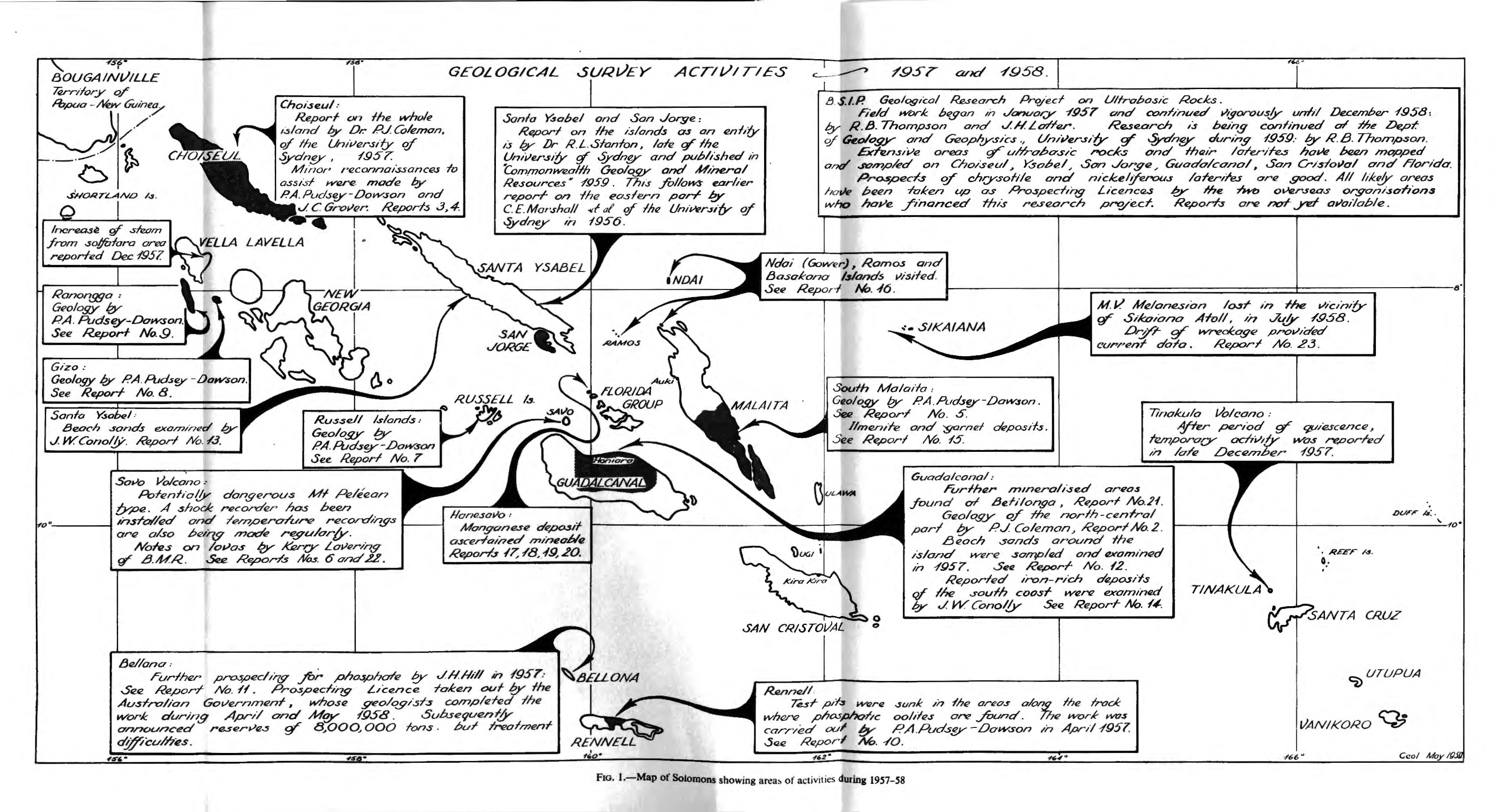
The basic work for any national Geological Survey is to produce geological maps of
its entire territory while concurrently searching for economically significant mineral
resources. The Chief Geologist, John Grover, now wished to extend this programme
to the Western Solomons where no systematic geological survey had ever been
attempted and Dick Stanton of New England University in Armidale, Australia and I
were given the task. I sailed from Honiara in early August 1959 on the Survey's
vessel Noula to set up a base camp on Oropie Island in the Wana Wana Lagoon
(where John F Kennedy's patrol torpedo boat was rammed by a Japanese destroyer
in August 1943). The Noula was a thirty-foot launch designed for ferry work in
Sydney harbour but in the Solomons it regularly went on ocean-going journeys, like
this one of 200 nautical miles, about 30 hours at cruising speed. On board we had
two dug-out canoes strapped alongside, a 500 gallon water tank roped on the cabin
roof, stores for two months, and 30 people: crew. Survey personnel and many
family members including women and small children. Mercifully, the weather was
benign. The Government's largest and newest vessel, the MV Melanesian, had
disappeared on 10 July 1958 with 64 people on board. Its loss was never explained
but a massive freak wave was one of the postulated reasons.
By 18 August with the Oropie camp established I was sitting on the stern of the
Noula, anchored offshore having breakfast when I heard shouting coming from the
island. When I asked one of the crew what was going on he told me they were
saying there was an earthquake happening. I had already felt several tremors in
Honiara but this time, nothing. On a ship you don't because the sea damps out the
motion. Then the ship's radio came on with the Chief Geologist telling me there had
been a major earthquake with early indications of epicentre near where I was and
several reports of heavy damage. I was to sail immediately for Gizo, the
administrative centre for the Western Solomons, about four hours sail, and report
back.
The earthquake measured 7.4 on the Richter scale then in use and caused
widespread structural damage but no loss of life. Ground fissures opened,
shorelines subsided and a seismic sea-wave swept away leaf houses in some
coastal villages. Stanton and I saw the most spectacular effects when we traversed
the island of Vella Lavella some time later. Large faults had been activated, causing
landslides that destroyed swathes of jungle, clogging rivers and causing flooding.
Hot springs appeared in some places and a thermal area of sulphur vents and mud
pools increased significantly in size.
The Solomon Islands form one segment of a tectonically extremely complex region
of the Pacific involving interactions between the Indo-Australian plate and the
Western Pacific plate. Earthquakes (now monitored by the Survey's seismic station)
are common and volcanoes, dormant and active, characterize the area. Savo Island
volcano, 14km north of Guadalcanal, is potentially the most dangerous. Its last
eruption, probably in about 1850, wiped out the entire population in pyroclastic flows of the kind that Vesuvius produced in AD 79, engulfing Pompeii. I made one visit to
Savo to check gas compositions and temperatures of the array localities that the
Survey established for monitoring the volcano. I visited two other Solomons
volcanoes, one, Simbo in the West, by design and the other, also in the West, by
accident. Activity on Simbo consists of hot springs and fumaroles (gas vents). Past
activity has been explosive causing evacuation of the population at times. The other
volcano was Kavachi, a submarine vent south of Vanguno Island at the eastern end
of the New Georgia group. From time to time (most recently in 2014) it erupts and
forms temporary Islands that are quickly washed away. One day in 1961 I was on
board the Government ship Veronica en route to Munda when we must have sailed
right over the Kavachi vent that exploded when the ship was about 500m away,
sending up a massive fountain of boiling seawater filled with glowing pieces of lava.
The skipper ordered full speed and we watched Kavachi repeat the performance
several times before dusk fell. One day Kavachi may become one of the new
permanent Solomon Islands.
Two non-geological experiences In the Solomons remain vivid in my memory. One
relates to the War of which there were many signs remaining in 1959-61: beached
Japanese transports, wrecked aircraft In the jungle, abandoned shattered barges
half-sunk in estuaries. Just before leaving for the West, I was called on by the Police
Chief. He told me that some Japanese soldiers had been seen foraging in a village
garden on New Georgia. "You take a rifle with you," he said. I assented—It was a
Lee Enfield .303 for protection against crocodiles. "Well, if you find them, bring them
in, will you?" "What if I can't persuade them?" "Shoot the buggers." Fortunately we
never saw them.
My other memory was of going with a crocodile shooter on one of his hunts, again in
the Western Solomons where the salt-water crocodile Is common. Hunting was
done after nightfall. A heavy dugout canoe carried three men, the hunter up front,
the paddler at the stern and. In this case me, in the middle with a powerful lamp
running off a car battery. The canoe went slowly along the riverbank with the lamp
light sweeping the sides. A crocodile's eyes glow red in the light. The shooter stands
up and aims between the eyes. The crocodile must then be secured alongside or In
the canoe in case it sinks and is lost. That Is the really exciting part, or so I was told.
We saw several sets of red eyes like car rear lights but the shooter judged all of the
targets unsuitable: they were all too large to take on.
|